As part of the MISO project, our recent intensive 𝐰𝐞𝐭𝐥𝐚𝐧𝐝 𝐟𝐢𝐞𝐥𝐝 𝐜𝐚𝐦𝐩𝐚𝐢𝐠𝐧 𝐚𝐭 𝐇𝐲𝐲𝐭𝐢𝐚̈𝐥𝐚̈ 𝐅𝐨𝐫𝐞𝐬𝐭 𝐒𝐭𝐚𝐭𝐢𝐨𝐧, 𝐅𝐢𝐧𝐥𝐚𝐧𝐝, brought our innovative drone system into action.
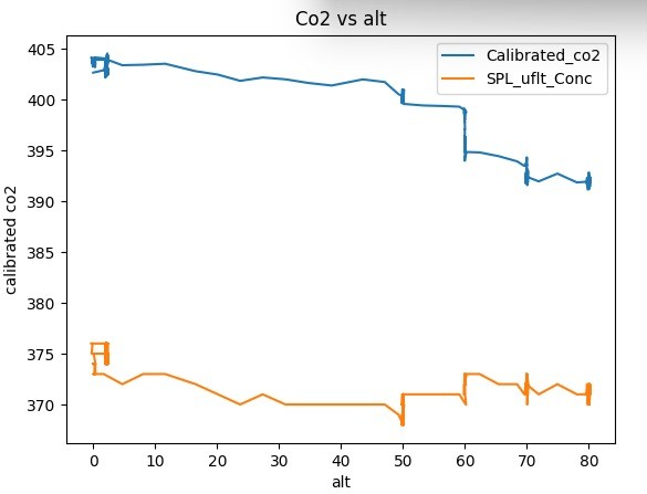
During the campaign, the MISO drone took to the skies to measure greenhouse gas concentrations both 𝐯𝐞𝐫𝐭𝐢𝐜𝐚𝐥𝐥𝐲 𝐚𝐧𝐝 𝐡𝐨𝐫𝐢𝐳𝐨𝐧𝐭𝐚𝐥𝐥𝐲 under real wetland conditions.
📈 𝐊𝐞𝐲 𝐅𝐢𝐧𝐝𝐢𝐧𝐠𝐬:
• Extensive drone flights at different altitudes revealed notable variations in CO₂ concentrations across heights.
• These insights are crucial for understanding how greenhouse gases behave in wetland ecosystems, helping refine our models and monitoring strategies.
🔬 This breakthrough is another step toward advancing environmental monitoring with cutting-edge drone technology.